Chapter 6C. Temporary Traffic Control Elements
Section 6C.01 Temporary
Traffic Control Plans
Support:
Whenever the acronym "TTC" is used in this Chapter, it
refers to "temporary traffic control."
Standard:
The needs and control of all road users (motorists, bicyclists,
and pedestrians within the highway, including persons with disabilities
in accordance with the Americans with Disabilities Act of 1990 (ADA),
Title II, Paragragh 35.130) through a TTC zone shall be an essential
part of highway construction, utility work, maintenance operations,
and the management of traffic incidents.
Support:
A TTC plan describes TTC measures to be used for facilitating road
users through a work zone or an incident area. TTC plans play a
vital role in providing continuity of reasonably safe and efficient
road user flow when a work zone, incident, or other event temporarily
disrupts normal road user flow. Important auxiliary provisions that
cannot conveniently be specified on project plans can easily be
incorporated into Special Provisions within the TTC plan.
TTC plans range in scope from being very detailed
to simply referencing typical drawings contained in this Manual,
standard approved highway agency drawings and manuals, or specific
drawings contained in the contract documents. The degree of detail
in the TTC plan depends entirely on the nature and complexity of
the situation.
Guidance:
TTC plans should be prepared by persons knowledgeable (for example,
trained and/or certified) about the fundamental principles of TTC
and work activities to be performed. The design, selection and placement
of TTC devices for a TTC plan should be based on engineering judgment.
Coordination should be made between adjacent or
overlapping projects to check that duplicate signing is not used
and to check compatibility of traffic control between adjacent or
overlapping projects.
Traffic control planning should be completed for
all highway construction, utility work, maintenance operations,
and incident management including minor maintenance and utility
projects prior to occupying the TTC zone. Planning for all road
users should be included in the process.
Provisions for effective continuity of accessible
circulation paths for pedestrians should be incorporated into the
TTC process. Where existing pedestrian routes are blocked or detoured,
information should be provided about alternative routes that are
usable by pedestrians with disabilities, particularly those who
have visual disabilities. Access to temporary bus stops, reasonably
safe travel across intersections with accessible pedestrian signals
(see Section 4E.06),
and other routing issues should be considered where temporary pedestrian
routes are channelized. Barriers and channelizing devices that are
detectable by people with visual disabilities should be provided.
Option:
Provisions may be incorporated into the project
bid documents that enable contractors to develop an alternate TTC
plan.
Modifications of TTC plans
may be necessary because of changed conditions or a determination
of better methods of safely and efficiently handling road users.
Guidance:
This alternate or modified plan should have the approval of the
responsible highway agency prior to implementation.
Provisions for effective continuity of transit
service should be incorporated into the TTC planning process because
often public transit buses cannot efficiently be detoured in the
same manner as other vehicles (particularly for short-term maintenance
projects). Where applicable, the TTC plan should provide for features
such as accessible temporary bus stops, pull-outs, and satisfactory
waiting areas for transit patrons, including persons with disabilities,
if applicable (see Section
10A.05 for additional light rail transit issues to consider
for TTC).
Provisions for effective continuity of railroad
service and acceptable access to abutting property owners and businesses
should also be incorporated into the TTC planning process.
Reduced speed limits should be used only in the
specific portion of the TTC zone where conditions or restrictive
features are present. However, frequent changes in the speed limit
should be avoided. A TTC plan should be designed so that vehicles
can reasonably safely travel through the TTC zone with a speed limit
reduction of no more than 16 km/h (10 mph).
A reduction of more than 16 km/h (10 mph) in the
speed limit should be used only when required by restrictive features
in the TTC zone. Where restrictive features justify a speed reduction
of more than 16 km/h (10 mph), additional driver notification should
be provided. The speed limit should be stepped down in advance of
the location requiring the lowest speed, and additional TTC warning
devices should be used.
Reduced speed zoning (lowering the regulatory
speed limit) should be avoided as much as practical because drivers
will reduce their speeds only if they clearly perceive a need to
do so.
Support:
Research has demonstrated that large reductions in the speed limit,
such as a 50 km/h (30 mph) reduction, increase speed variance and
the potential for crashes. Smaller reductions in the speed limit
of up to 16 km/h (10 mph) cause smaller changes in speed variance
and lessen the potential for increased crashes. A reduction in the
regulatory speed limit of only up to 16 km/h (10 mph) from the normal
speed limit has been shown to be more effective.
Section 6C.02 Temporary
Traffic Control Zones
Support:
A TTC zone is an area of a highway where road user conditions are
changed because of a work zone or an incident through the use of
TTC devices, uniformed law enforcement officers, or other authorized
personnel.
A work zone is an area of
a highway with construction, maintenance, or utility work activities.
A work zone is typically marked by signs, channelizing devices,
barriers, pavement markings, and/or work vehicles. It extends from
the first warning sign or high-intensity rotating, flashing, oscillating,
or strobe lights on a vehicle to the END ROAD WORK sign or the last
TTC device.
An incident area is an area
of a highway where temporary traffic controls are imposed by authorized
officials in response to a traffic incident, natural disaster, or
special event. It extends from the first warning device (such as
a sign, light, or cone) to the last TTC device or to a point where
road users return to the original lane alignment and are clear of
the incident.
Section 6C.03 Components
of Temporary Traffic Control Zones
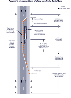
Support:
Most TTC zones are divided into four areas: the advance warning
area, the transition area, the activity area, and the termination
area. Figure 6C-1 illustrates these four areas. These four areas
are described in Sections 6C.04
through 6C.07.
Figure
6C-1 Component Parts of a Temporary Traffic Control Zone
Section 6C.04 Advance
Warning Area
Support:
The advance warning area is the section of highway where road users
are informed about the upcoming work zone or incident area.
Option:
The advance warning area may vary from a single sign or high-intensity
rotating, flashing, oscillating, or strobe lights on a vehicle
to a series of signs in advance of the TTC zone activity area.
Guidance:
Typical distances for placement of advance warning signs on freeways
and expressways should be longer because drivers are conditioned
to uninterrupted flow.Therefore, the advance warning sign placement
should extend on these facilities as far as 800 m (0.5 mi) or more.
On urban streets, the effective placement of the
first warning sign in meters (feet) should range from 0.75 to 1.5
times the speed limit in km/h (4 to 8 times the speed limit in mph),
with the high end of the range being used when speeds are relatively
high. When a single advance warning sign is used (in cases such
as low-speed residential streets), the advance warning area can
be as short as 30 m (100 ft). When two or more advance warning signs
are used on higher-speed streets, such as major arterials, the advance
warning area should extend a greater distance (see Table 6C-1).
Table 6C-1. Suggested Advance Warning
Sign Spacing
| Road
Type |
Distance
Between Signs** |
| A |
B |
C |
| Urban (low
speed)* |
30
(100) |
30
(100) |
30
(100) |
| Urban (high
speed)* |
100
(350) |
100
(350) |
100
(350) |
| Rural |
150
(500) |
150
(500) |
150
(500) |
| Expressway
/ Freeway |
300
(1,000) |
450
(1,500) |
800 (2,640) |
* Speed category
to be determined by highway agency
** Distances are shown in meters (feet).
The column headings A, B, and C are the dimensions shown in Figures
6H-1 through
6H-46.
The A dimension is the distance from the transition or point of
restriction to the first sign. The B dimension is the distance between
the first and second signs. The C dimension is the distance between
the second and third signs. (The third sign is the first one in
a three-sign series encountered by a driver approaching a TTC zone.) Since rural highways are normally characterized
by higher speeds, the effective placement of the first warning sign
in meters (feet) should be substantially longer—from 1.5 to
2.25 times the speed limit in km/h (8 to 12 times the speed limit
in mph). Since two or more advance warning signs are normally used
for these conditions, the advance warning area should extend 450
m (1,500 ft) or more for open highway conditions (see Table 6C-1).
Option:
Advance warning may be eliminated when the activity area is sufficiently
removed from the road users' path so that it does not interfere
with the normal flow.
Section 6C.05 Transition
Area
Support:
The transition area is that section of highway where road users
are redirected out of their normal path. Transition areas usually
involve strategic use of tapers, which because of their importance
are discussed separately in detail.
Standard:
When redirection of the road users' normal path is required, they
shall be channelized from the normal path to a new path.
Support:
In mobile operations, the transition area moves with the work space.
Section 6C.06 Activity
Area
Support:
The activity area is the section of the highway where the work activity
takes place. It is comprised of the work space, the traffic space,
and the buffer space.
The work space is that portion of the highway closed
to road users and set aside for workers, equipment, and material,
and a shadow vehicle if one is used upstream. Work spaces are usually
delineated for road users by channelizing devices or, to exclude
vehicles and pedestrians, by temporary barriers.
Option:
The work space may be stationary or may move as work progresses.
Guidance:
Since there might be several work spaces (some even separated by
several kilometers or miles) within the project limits, each work
space should be adequately signed to inform road users and reduce
confusion.
Support:
The traffic space is the portion of the highway in which road users
are routed through the activity area.
The buffer space is a lateral and/or longitudinal
area that separates road user flow from the work space or an unsafe
area, and might provide some recovery space for an errant vehicle.
Guidance:
Neither work activity nor storage of equipment, vehicles, or material
should occur within a buffer space.
Option:
Buffer spaces may be positioned either longitudinally or laterally
with respect to the direction of road user flow. The activity area
may contain one or more lateral or longitudinal buffer spaces.
A longitudinal buffer space may be placed in advance
of a work space.
The longitudinal buffer space may also be used to
separate opposing road user flows that use portions of the same
traffic lane, as shown in Figure 6C-2.
If a longitudinal buffer space is used, the values
shown in Table 6C-2 may be used to determine the length of the longitudinal
buffer space.
Figure
6C-2 Types of Tapers and Buffer Spaces
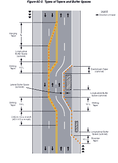
Table 6C-2. Stopping Sight Distance
as a Function of Speed
Speed*
(km/h) |
Distance
(m) |
Speed*
(mph) |
Distance
(ft) |
| 30 |
35 |
20 |
115 |
| 40 |
50 |
25 |
155 |
| 50 |
65 |
30 |
200 |
| 60 |
85 |
35 |
250 |
| 70 |
105 |
40 |
305 |
| 80 |
130 |
45 |
360 |
| 90 |
160 |
50 |
425 |
| 100 |
185 |
55 |
495 |
| 110 |
220 |
60 |
570 |
| 120 |
250 |
65 |
645 |
 |
|
70 |
730 |
|
|
75 |
820 |
*
Posted speed, off-peak 85th-percentile speed prior to work starting,
or the anticipated operating speed Support:
Typically, the buffer space is formed as a traffic island and defined
by channelizing devices.
When a shadow vehicle, arrow panel, or changeable
message sign is placed in a closed lane in advance of a work space,
only the area upstream of the vehicle, arrow panel, or changeable
message sign constitutes the buffer space.
Option:
The lateral buffer space may be used to separate the traffic space
from the work space, as shown in Figures 6C-1
and 6C-2, or such areas
as excavations or pavement-edge drop-offs. A lateral buffer space
also may be used between two travel lanes, especially those carrying
opposing flows.
Guidance:
The width of a lateral buffer space should be determined by engineering
judgment.
Option:
When work occurs on a high-volume, highly congested facility, a
vehicle storage or staging space may be provided for incident response
and emergency vehicles (for example, tow trucks and fire apparatus)
so that these vehicles can respond quickly to road user incidents.
Guidance:
If used, an incident response and emergency-vehicle storage area
should not extend into any portion of the buffer space.
Section 6C.07 Termination
Area
Standard:
The termination area shall be used to return road users to their
normal path. The termination area shall extend from the downstream
end of the work area to the last TTC device such as END ROAD WORK
signs, if posted.
Option:
An END ROAD WORK sign, a Speed Limit sign, or other signs may be
used to inform road users that they can resume normal operations.
A longitudinal buffer space may be used between
the work space and the beginning of the downstream taper.
Section 6C.08 Tapers
Option:
Tapers may be used in both the transition and termination areas.
Whenever tapers are to be used in close proximity to an interchange
ramp, crossroads, curves, or other influencing factors, the length
of the tapers may be adjusted.
Support:
Tapers are created by using a series of channelizing devices and/or
pavement markings to move traffic out of or into the normal path.
Types of tapers are shown in Figure 6C-2.
Longer tapers are not necessarily better than shorter
tapers (particularly in urban areas with characteristics such as
short block lengths or driveways) because extended tapers tend to
encourage sluggish operation and to encourage drivers to delay lane
changes unnecessarily. The test concerning adequate lengths of tapers
involves observation of driver performance after TTC plans are put
into effect.
Guidance:
The appropriate taper length (L) should be determined using the
criteria shown in Tables 6C-3 and 6C-4.
The maximum distance in meters (feet) between
devices in a taper should not exceed 0.2 times the speed limit in
km/h (1.0 times the speed limit in mph).
Table 6C-3. Taper Length Criteria
for Temporary Traffic Control Zones
| Type of Taper |
Taper Length (L)* |
| Merging Taper |
at least L |
| Shifting Taper |
at least 0.5L |
| Shoulder Taper |
at least 0.33L |
| One-Lane, Two-Way Traffic Taper |
30 m (100 ft) maximum |
| Downstream Taper |
30 m (100 ft) per lane |
Support:
A merging taper requires the longest distance because drivers are
required to merge into common road space.
Guidance:
A merging taper should be long enough to enable merging drivers
to have adequate advance warning and sufficient length to adjust
their speeds and merge into a single lane before the end of the
transition.
Support:
A shifting taper is used when a lateral shift is needed. When more
space is available, a longer than minimum taper distance can be
beneficial. Changes in alignment can also be accomplished by using
horizontal curves designed for normal highway speeds.
Guidance:
A shifting taper should have a length of approximately 0.5 L (see
Tables 6C-3 and 6C-4).
Support:
A shoulder taper may be beneficial on a high-speed roadway where
shoulders are part of the activity area and are closed, or when
improved shoulders might be mistaken as a driving lane. In these
instances, the same type, but abbreviated, closure procedures used
on a normal portion of the roadway can be used.
Where:
L = taper length in meters (feet)
W = width of offset in meters (feet)
S = posted speed limit, or off-peak 85th-percentile
speed prior to work starting, or the anticipated operating speed
in km/h (mph).
Guidance:
If used, shoulder tapers should have a length of approximately 0.33
L (see Tables 6C-3 and
6C-4). If a shoulder
is used as a travel lane, either through practice or during a TTC
activity, a normal merging or shifting taper should be used.
Option:
A downstream taper may be useful in termination areas to provide
a visual cue to the driver that access is available back into the
original lane or path that was closed.
Guidance:
When used, a downstream taper should have a length of approximately
30 m (100 ft) per lane with devices placed at a spacing of approximately
6.1 m (20 ft).
Support:
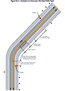
The one-lane, two-way taper is used in advance of an activity area
that occupies part of a two-way roadway in such a way that a portion
of the road is used alternately by traffic in each direction.
Guidance:
Traffic should be controlled by a flagger or temporary traffic control
signal (if sight distance is limited), or a STOP or YIELD sign.
A short taper having a maximum length of 30 m (100 ft) with channelizing
devices at approximately 6.1 m (20 ft) spacings should be used to
guide traffic into the one-way section.
Support:
An example of a one-lane, two-way traffic taper is shown in Figure
6C-3.
Figure
6C-3 Example of a One-Lane, Two-Way Traffic Taper
Section 6C.09 Detours
and Diversions
Support:
A detour is a temporary rerouting of road users onto an existing
highway in order to avoid a TTC zone.
Guidance:
Detours should be clearly signed over their entire length so that
road users can easily use existing highways to return to the original
highway.
Support:
A diversion is a temporary rerouting of road users onto a temporary
highway or alignment placed around the work area.
Section 6C.10 One-Lane,
Two-Way Traffic Control
Standard:
When traffic in both directions must use a single lane for a limited
distance, movements from each end shall be coordinated.
Guidance:
Provisions should be made for alternate one-way movement through
the constricted section via methods such as flagger control, a flag
transfer, a pilot car, traffic control signals, or stop or yield
control.
Control points at each end should be chosen to
permit easy passing of opposing lanes of vehicles.
If traffic on the affected one-lane roadway is
not visible from one end to the other, then flagging procedures,
a pilot car with a flagger used as described in Section
6F.54, or a traffic control signal should be used to control
opposing traffic flows.
Support:
At a spot constriction, such as an isolated pavement patch on highways
with lower speeds and adequate sight distance, the movement of traffic
through one-lane, two-way constrictions tends to be self-regulating.
Section 6C.11 Flagger
Method of One-Lane, Two-Way Traffic Control
Option:
When a one-lane, two-way TTC zone is short enough to allow a flagger
to see from one end of the zone to the other, traffic may be controlled
by either a single flagger or by a flagger at each end of the section.
Guidance:
When a single flagger is used, the flagger should be stationed on
the shoulder opposite the constriction or work space, or in a position
where good visibility and traffic control can be maintained at all
times. When good visibility and traffic control cannot be maintained
by one flagger station, traffic should be controlled by a flagger
at each end of the section. One of the flaggers should be designated
as the coordinator. Flaggers should be able to communicate with
each other orally, electronically, or with manual signals. These
manual signals should not be mistaken for flagging signals.
Section 6C.12 Flag
Transfer Method of One-Lane, Two-Way Traffic Control
Support:
The driver of the last vehicle proceeding into the one-lane section
is given a red flag (or other token) and instructed to deliver it
to the flagger at the other end. The opposite flagger, upon receipt
of the flag, then knows that it is reasonably safe to allow traffic
to move in the other direction. A variation of this method is to
replace the use of a flag with an official pilot car that always
follows the last road user vehicle proceeding through the section.
Guidance:
The flag transfer method should be employed only where the one-way
traffic is confined to a relatively short length of a road, usually
not more than 1.6 km (1 mi) in length.
Section 6C.13 Pilot
Car Method of One-Lane, Two-Way Traffic Control
Option:
A pilot car may be used to guide a queue of vehicles through the
TTC zone or detour.
Guidance:
The operation of the pilot vehicle should be coordinated with flagging
operations or other controls at each end of the one-lane section.
The pilot car should have the name ofthe contractor or contracting
authority prominently displayed.
Standard:
The PILOT CAR FOLLOW ME (G20-4) sign (see Figure
6F-4, Sheet 4) shall be mounted at a conspicuous location on
the rear of the vehicle.
Section 6C.14 Temporary
Traffic Control Signal Method of One-Lane, Two-Way Traffic Control
Option:
Traffic control signals may be used to control vehicular traffic
movements in one-lane, two-way TTC zones (see Figure
6H-12 and Chapter 4G).
Section 6C.15 Stop
or Yield Control Method of One-Lane, Two-Way Traffic Control
Option:
STOP or YIELD signs may be used to control traffic on low-volume
roads at a one-lane, two-way TTC zone when drivers are able to see
the other end of the one-lane, two-way operation and have sufficient
visibility of approaching vehicles.
Guidance:
If the STOP or YIELD sign is installed for only one direction, then
the STOP or YIELD sign should face road users who are driving on
the side of the roadway that is closed for the work activity area.
Back to Top
|