|
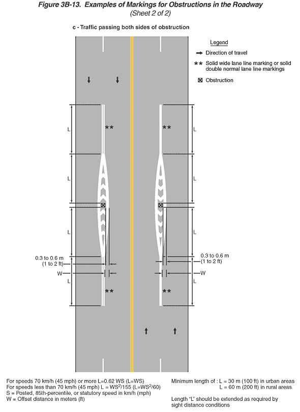
Figure 3B-13. Examples of Markings for Obstructions in the Roadway
(Sheet 2 of 2)
This figure illustrates three examples of markings for obstructions
in the roadway.
- Sheet 2 of the figure shows one vertical highway, example (c).
Notes state "For speeds 70 km/h (45 mph) or more L = 0.62
WS (L = WS). For speeds less than 70 km/h (45 mph) L = WS2/155
(L = WS2/60). S = posted, 85th percentile, or statutory speed
in km/h (mph). W = offset distance in meters (ft). Minimum length
of L = 30 m (100 ft) in urban areas and 60 m (200 ft) in rural
areas. Length 'L' should be extended as required by sight distance
conditions."
A legend shows a black arrow indicating the direction of travel
in the lanes, a double asterisk denoting "200 mm (8 in) solid
lane line markings or double 100 mm (4 in) solid lane line markings,"
and a black "x" inscribed in a square denoting an obstruction.
- The third example is labeled "c - Traffic passing
both sides of obstruction." It shows two northbound lanes
with an obstruction in an island formed by south-pointing white
chevrons in the center of the two lanes to the right of two southbound
lanes with an obstruction in an island formed by north-pointing
white chevrons in the center of the two lanes. Arrows show that
the direction of travel is two lanes in each direction. A solid
double yellow line separates the opposing lanes. In the northbound
lanes, starting from the bottom of the figure, a broken white
line separates the through lanes from each other and then changes
to a solid white line as it approaches the obstruction, then it
separates into two tapering solid white lines, one on each side
of the obstruction. Beyond the obstruction, the two solid double
white lines taper back to merge into one solid double white line
at the center of the roadway. The one solid double white line
then continues along the center of the road and changes to a broken
single white line as it approaches the top of the illustration.
Several dimensions are shown on the figure. "W" is shown
as the offset from the normal center of the roadway to the outside
edge of the solid white line immediately opposite the obstruction.
That outside edge of the solid white line is shown as 0.3 to 0.6
m (1 to 2 ft). "L" is shown as the longitudinal distance
along the roadway for the taper of the solid double white line(s)
from the normal center of the roadway to the greatest width of
the channelizing island at the obstruction. The dimension of the
solid white line on either side of the channelizing island also
is shown as "L." Double asterisks are shown next to
the single and double white lines on either side of the island,
denoting: "solid wide lane line markings or solid double
normal lane line markings." A series of white chevron lines,
running from north to south at 45-degree angles, are shown filling
the parallelogram-shaped island between the two solid double white
lines in the northbound lanes. In the southbound lanes, the same
island configuration, lane markings, and double asterisks are
shown as in the northbound lanes, except the solid white line
on either side of the channelizing island is shown as a solid
double white line. The dimensions shown are the same as for the
northbound lanes. A series of white chevron lines, running from
south to north at 45-degree angles, are shown filling the island
in the southbound lanes.
Back to: Sheet 1
Back
to Chapter 3B
|