|
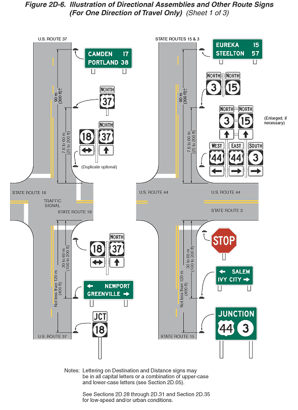
Figure 2D-6. Illustration of Directional Assemblies and Other Route
Signs (For One Direction of Travel Only) (Sheet 1 of 3)
This figure shows illustrations of directional assemblies and other
route signs along one direction of travel on several highways. The
figure is composed of three sheets.
- Sheet 1 of the figure shows two highway intersections. Notes
state "Lettering on Destination and Distance signs may be
in all capital letters or a combination of upper-case and lower-case
letters (see Section 2D.05)."
and "See Sections 2D.28
through 2D.31
and Section 2D.35 for low-speed
and/or urban conditions."
- On the left side of sheet 1, a highway is shown labeled "U.S.
ROUTE 37" running vertically and intersecting a highway
running horizontally labeled "STATE ROUTE 18." The
words "TRAFFIC SIGNAL" are shown in the middle of
the intersection. This figure shows a vertical and a horizontal
two-lane roadway with one lane of traffic in each direction.
Near the intersection, the opposing lanes are shown separated
by a solid double yellow line. Farther away from the intersection
on the vertical roadway, the opposing lanes in each direction
are shown separated from each other by a broken yellow line.
Solid white stop lines are shown across the approach lane on
each side of the intersection. The direction of travel is from
the bottom to the top of the figure. There are six sign assemblies
shown on the vertical highway, all shown on the right side of
the highway:
- At the bottom of the figure, a sign assembly is shown composed
of a horizontal rectangular white "JCT" junction
sign mounted above a square black state route sign with the
numeral "18" displayed on a white disc. The distance
from the near side of the intersection to this sign assembly
is shown as a dimension of not less than 120 m (400 ft). Further
up the page, a horizontal rectangular green sign is shown
with a left-pointing horizontal arrow and the word "NEWPORT"
on the top line and the word "GREENVILLE" and a
right-pointing horizontal arrow on the bottom line. The distance
from the near side of the intersection to this sign is shown
as a dimension of 30 to 60 m (100 to 200 ft).
- Just prior to the intersection, at the start of the corner
radius, a sign assembly is shown composed of five signs. On
the left side of the assembly, a square black state route
sign is shown with the numeral "18" displayed on
a white disc mounted above a horizontal rectangular sign with
a black two-headed horizontal arrow on a white background.
On the right side of the assembly, a white horizontal rectangular
sign is shown with the word "NORTH" that is mounted
above a square black U.S. route marker with the numeral "37"
displayed on a white shield that is mounted above a horizontal
rectangular white sign with an upward-pointing vertical black
arrow.
- Just beyond the intersection, at the end of the corner radius,
a sign assembly identical to the one on the near side of the
intersection is shown. Below this sign assembly is the notation
"Duplicate optional."
- Further up the page, a sign assembly is shown with a white
horizontal rectangular sign with the word "NORTH"
mounted above a square black U.S. Route marker with the numeral
"37" displayed on a white shield. The distance from
the uppermost side of the intersection to this sign assembly
is shown as a dimension of 7.6 to 60 m (25 to 200 ft).
- At the top of the illustration, a horizontal rectangular
green sign is shown with the word "CAMDEN" to the
left of the numeral "17" on the top line and the
word "PORTLAND" to the left of the numeral "38"
on the bottom line. The distance from the uppermost side of
the intersection to this sign assembly is shown as a dimension
of 90 m (300 ft) +.
- On the right side of sheet 1, a vertical highway is shown
labeled "STATE ROUTES 15 & 3" at the top of the
figure and "STATE ROUTE 15" at the bottom. This highway
runs vertically and intersects a highway running horizontally
labeled "U.S. ROUTE 44" to the left and "U.S.
ROUTE 44" and "STATE ROUTE 3" on the right. This
figure shows the vertical and horizontal two-lane roadways with
one lane of traffic in each direction. Near the intersection,
the opposing lanes are shown separated by a solid double yellow
line. Farther away from the intersection on the vertical roadway,
the opposing lanes in each direction are shown separated from
each other by a broken yellow line. Solid white stop lines are
shown across the approach lanes at the intersection on the vertical
roadway. The direction of travel is from the bottom to the top
of the figure. There are six sign assemblies shown on the vertical
highway, all shown on the right side of the highway:
- At the bottom of the figure, a horizontal rectangular green
sign is shown with the word "JUNCTION" in white
on the top line and the numeral "44" displayed on
a white shield to the left of the numeral "3" displayed
on a white disc. The distance from the near side of the intersection
to this sign is shown as a dimension of not less than 120
m (400 ft).
- Further up the page, a horizontal rectangular green sign
is shown with a left-pointing horizontal white arrow and the
word "SALEM" in white on the top line and the word
"IVY CITY" in white and a right-pointing horizontal
white arrow on the bottom line. The distance from the near
side of the intersection to this sign is shown as a dimension
of 30 to 60 m (100 to 200 ft).
- Just prior to the intersection, at the start of the corner
radius and next to the white stop line, a red STOP sign is
shown.
- Just beyond the intersection, at the end of the corner radius,
five sign assemblies are shown, with two assemblies mounted
above three assemblies. On the top, an assembly is shown of
a horizontal rectangular white sign with the word "NORTH"
mounted above a square black state route sign with the numeral
"3" above an upward-pointing vertical black arrow.
To the right, the same sign assembly is shown but substituting
the numeral "15." Below these two signs are three
sign assemblies. On the left, a horizontal rectangular white
sign is shown with the word "WEST" in black mounted
above a U.S. route marker with the numeral "44"
in black displayed on a white shield and above a horizontal
rectangular white sign with a left-pointing horizontal black
arrow. To the right is shown the same sign assembly substituting
"EAST" and the horizontal arrow pointing to the
right. On the far right, a sign assembly is shown with a horizontal
rectangular white sign with the word "SOUTH" in
black above a state route sign with the numeral "3"
in black on a white disc above a horizontal rectangular white
sign with a right-pointing horizontal black arrow. To the
right of this sign assembly is the notation "Enlarged,
if necessary."
- Further up the page, a sign assembly is shown with a horizontal
rectangular white sign with the word "NORTH" in
black mounted above a square black state route sign with the
numeral "3" in black displayed on a white disc.
This sign assembly is shown next to a horizontal rectangular
white sign with the word "NORTH" in black mounted
above a square black state route sign with the numeral "15"
in black displayed on a white disc. The distance from the
far side of the intersection to this sign assembly is shown
as a dimension of 7.6 to 60 m (25 to 200 ft).
- At the top of the illustration, a horizontal rectangular
green sign is shown with the word "EUREKA" in white
to the left of the numeral "15" in white on the
top line above the word "STEELTON" in white to the
left of the numeral "57" in white. The distance
from the far side of the intersection to this sign is shown
as a dimension of 90 m (300 ft) +.
Continue to: Sheet 2 | Sheet
3
Back
to Chapter 2D
|