|
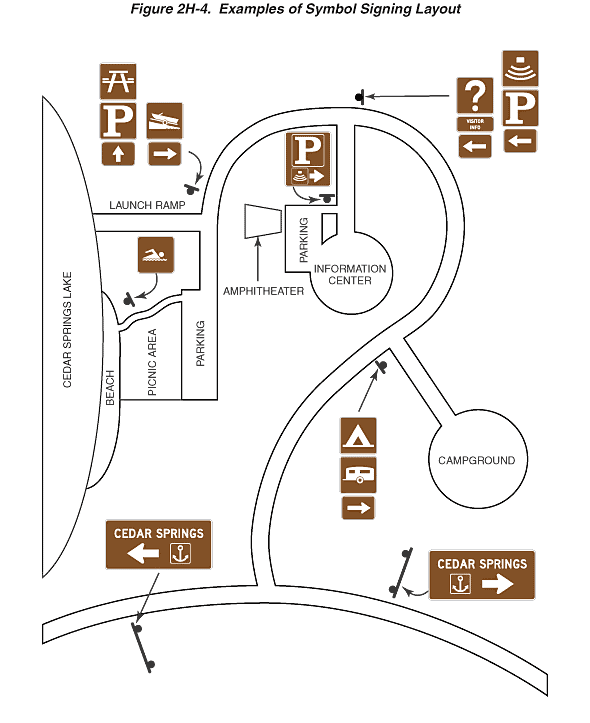
Figure 2H-4. Examples of Symbol Signing Layout
This figure illustrates examples of symbol signing layout within
a recreational or cultural area. A plan view area map is shown of
Cedar Springs marina, depicting a main road at the bottom of the
figure, a marina complex entry road that leads into the marina complex
from the main roadway, and internal roadways and facilities within
the marina complex.
On the main road, a horizontal rectangular brown guide sign is
shown on each right-hand side of the road in advance of the intersection
with the marina complex entry road, displaying the words "CEDAR
SPRINGS" on the first line and a marine recreation area symbol
sign (anchor enclosed within a square white border) and a horizontal
arrow pointing into the area on the second line.
At the intersection of the marina complex entry road and an internal
access road to the right toward a campground, a sign assembly is
shown at the near right corner of the intersection, facing traffic
entering the complex. This assembly is shown with a camping symbol
sign mounted above a trailer symbol sign, which is above a right-pointing
horizontal arrow sign.
The entry road is shown continuing and curving up and to the left
and intersecting an access road on the left that leads to a parking
area, amphitheater, and information center. A sign assembly is shown
on the right side of the entry road on the near side of the intersection
with this access road. The left portion of the sign assembly is
composed of an information symbol sign (question mark enclosed within
a square white border) mounted above a square plaque with the words
"VISITOR INFO" on two lines, which is above a left-pointing
horizontal arrow sign. The right portion of the sign assembly is
shown composed of an amphitheater symbol sign mounted above a parking
symbol sign ("P"), which is above a left-pointing horizontal
arrow sign. On the access road at the entrance to the parking area,
a vertical rectangular sign is shown that includes a parking symbol
("P" enclosed within a square white border) on the top
portion of the sign and a smaller amphitheater symbol (enclosed
within a square white border) and a right-pointing horizontal arrow
on the bottom portion of the sign.
The marina complex entry road is shown continuing to curve to the
left and down toward another parking area. It is shown intersecting
a road to the right that is labeled "Launch Ramp." At
the intersection with the Launch Ramp, a sign assembly is shown
on the right side of the entry road at the near side of the intersection.
The left side of this assembly is shown composed of a picnic area
symbol sign, parking symbol sign ("P"), and upward-pointing
vertical arrow sign. The right side of this assembly is shown composed
of a launch ramp symbol sign and a right-pointing horizontal arrow
sign.
The marina complex entry road is shown continuing downward past
the Launch Ramp and ending as it enters a parking area. A narrower
roadway or path is shown leading out of the parking lot and past
a picnic area to a beach. In front of the beach, facing the narrower
roadway or path a swimming symbol sign is shown.
Back
to Chapter 2H
|