|
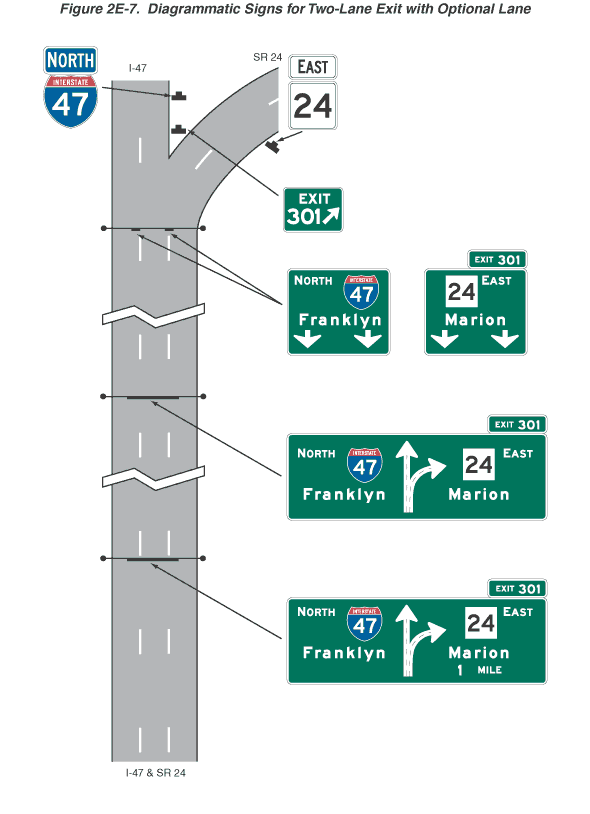
Figure 2E-7. Diagrammatic Signs for Two-Lane Exit with Optional
Lane
This figure shows diagrammatic signs for a two-lane exit with an
optional lane.
The figure shows segments of one direction of a vertical highway
labeled I-47 &SR 24 at the bottom of the figure, depicted with
three lanes, with the travel direction from the bottom to the top
of the figure. Near the top of the figure, the center lane divides,
and the left lane and a center lane (labeled I-47) are shown continuing
straight, and a center lane and the right lane (labeled SR 24) are
shown curving to the right. A series of five horizontal rectangular
green signs and sign assemblies with white legends and borders are
shown along the highway from the bottom to the top of the figure,
as well as route signs.
The first sign is shown extending from the middle of the left lane,
over the center lane, and to the middle of the right lane of the
highway. It is shown with a plan view of the exit in the middle
of the sign, consisting of a two-headed arrow with the two shafts
emanating from a combined base, with one shaft pointed straight
ahead and the other curving up and to the right. Each shaft is shown
with a dashed green line along the middle of the shaft from the
base to the start of the arrowhead:
- To the left of the plan view, on the top line, the word "NORTH"
is shown to the left of a red and blue Interstate route shield
on which the white numerals "47" are shown, and the
word "Franklyn" is shown on the bottom line.
- To the right of the plan view, on the top line, a white square
is shown on which the black numerals "24" are shown
to the left of the word "EAST," the word "Marion"
is shown on the middle line, and the words "1 MILE"
are shown on the bottom line.
- A smaller horizontal rectangular green plaque is shown above
the top right side of the sign. It shows the words "EXIT
301."
The second sign is also shown extending from the middle of the
left lane, over the center lane, and to the middle of the right
lane of the highway. This sign and its plaque are shown as identical
to the first sign and plaque except that the words "1 MILE"
under the word "Marion" are deleted.
Just before the divergence, a sign assembly is shown located over
the highway. The assembly consists of two signs in a horizontal
array:
- The left sign is shown located above the lane line that separates
the left and center lanes. It shows, on the top line, the word
"NORTH" to the left of a red and blue Interstate route
shield on which the white numerals "47" are shown, the
word "Franklyn" on the middle line, and two downward-pointing
vertical white arrows with short shafts on the bottom line.
- The right sign is shown located above the lane line that separates
the center and right lanes. It shows, on the top line, a white
square on which the black numerals "24" are shown to
the left of the word "EAST," the word "Marion"
on the middle line, and two downward-pointing vertical white arrows
with short shafts on the bottom line.
- A smaller horizontal rectangular green plaque is shown above
the top right side of the sign. It shows the words "EXIT
301."
Just at the point of divergence, a smaller horizontal rectangular
sign is shown on the gore between the lanes that curve to the left
and the lanes that continue straight ahead. It shows the word "EXIT"
on the top line and the numerals "301" to the left of
a large white diagonal arrow with a short shaft pointing up and
to the right on the bottom line.
Just beyond the divergence, a sign is shown to the right of the
lanes that continue straight ahead. It is a red and blue Interstate
route shield on which the white numerals "47" are shown.
Above it, a plaque is shown with the word "NORTH" in white
letters and a white border on a blue background. Just beyond the
divergence, a sign is shown to the right of the lanes that curve
to the right. It is a white square on which the black numerals "24"
are shown. Above it, a plaque is shown with the word "EAST"
in black letters and a black border on a white background.
Back
to Chapter 2E
|